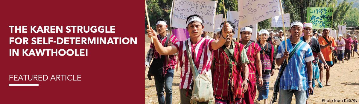
Karen Environmental Social Action Network (KESAN) / IPMSDL | August 21, 2018
This article is a case study conducted and written by KESAN (Karen Environmental Social Action Network) contributed for #IDWIP2018.
Burma is one of the most ethnically diverse countries in the world, and while ethnic Burmans represent a majority in the central Irrawaddy river-plain, non-Burman ethnic groups inhabit about half of the country making up over one-third of the population, forming a relative majority in the great horseshoe of mountains which surround the central lowlands. Situated between modern-day Bangladesh, India, China, Laos and Thailand, the country’s ethno-linguistic diversity reflects the regions rich histories of migration. According to research carried out by linguists and anthropologists, the different ethnic sub-groups in Burma can are related to “four main families: the Tibeto-Burmese, Mon-Khmer, Shan (or Tai) and Karen.”
Although the geographic origins of Karen are disputed, historians believe that the Karen people, with a number of sub-groups or tribes, migrated from Tibet and the upper reaches of Yangtze River in China nearly three thousand years ago. Today, the Karen represent one of the largest ethnic nationalities in Burma, their number ranging from 3 to 7 million[2]. Regardless of population size or migratory origins, non-Burman ethnic nationalities in modern day Burma share a common struggle against subjugation and oppression by the Burman dominated military-state complex.
Geographically, ethnic Karen-related people populate a wide area of modern day Burma, stretching from the southern Irrawaddy delta across Rangoon, Bago and Tanawthari (Tanintharyi) regions and the Karen, Karenni, Mon and Shan States, branching across the country’s borders into the mountain ranges of western Thailand. Karen ethnic-related groups include the “S’gaw Karen, Pwo Karen, Bwe Karen, Paku Karen, Mobwa Karen, Geba Karen and Karen Phyu”.[3] Although Karen-related people have distinct political identities and speak mutually unintelligible languages, “they are connected through customs, traditions, and a long history of shared communities, and thus a sense of unity in diversity.”[4] Commonly, inside Burma, the Karen ethno-nationalist group refers to the S’gaw and Pwo speaking Karens inhabiting areas of the Irrawaddy, Rangoon, Bago and Tanawthari regions and the Karen, Karenni and Mon states.
“Seven decades of civil war between Karen and Burmese forces has had a significant impact on Mutraw District’s communities and environment… the root causes of that conflict remain sorely unaddressed”
In February 1947, the Karen National Union (KNU) was founded as an umbrella group of four Karen social, political, and religious organizations with the aim of advancing the Karen national cause, with broad support across Karen-populated territories. This came shortly after Burma’s independence leader Aung San signed a deal with the British government that pledged to form an independent Burma “as soon as possible”[5], also succeeding in concluding an agreement for a unified Burma at the Panglong Conference on 12 February. However, this fragile amity was thrown into disarray following the tragic assassination of Aung San on July 19, 1947, and the rapid exit of the British. When Burma became independent on the 4th of January 1948, led by the country’s first independent government, the Anti-Fascist People’s Freedom League, many critical issues remained unresolved. While the independence government awarded the voluntary right to secession to the Shan and Karenni they refused to agree to Karen demands for equality and autonomy, promised by Aung San. On February 11, 1948, four hundred thousand Karen people staged silent demonstrations nationwide, with demands for a state, equality and freedom.[6]
In 1949, the Karen revolution began after failure of the Union Government and the Karen National Union to reach an agreement over the terms of a Karen State, known by the Karen people as Kawthoolei. Until now the Karen people continue the struggle for self-determination. This struggle, which continues until this day, represents the longest civil-war in Myanmar, and, by many accounts, the longest running civil war in the world.
In the seven decades since Burma wrested independence from British imperial rule, armed conflict, political upheaval and civil war has pushed the Karen struggle for self-determination into shrinking and fragmented spaces of resistance in the country’s southeast. In the last three decades alone, the Burma Army’s military campaigns and occupation have forced hundreds of thousands of Karen people from their ancestral territories, many fleeing for their lives across the country’s borders into Thailand.
State Violence and Local Resilience in Mutraw
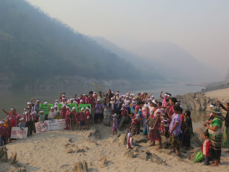
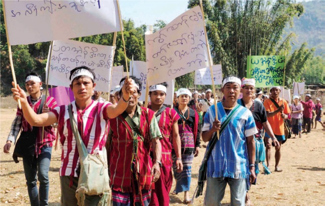
Karen IDP communities demonstrate their opposition the large-dams on the Salween River, March 2017. Photo from KESAN.
In the early 1990s, the Burma Army began its most coordinated and widespread military campaigns in the east and southeast of the country. In Mutraw (Hpapun), the mountainous district of northeastern Karen State, troops of the Burma Army systematically and indiscriminately targeted civilian areas violently displacing eighty percent of the district’s original 107,000 inhabitants[7] with many fleeing to refugee camps along the Thai border, while others chose to live in hiding in the forests. Although the Burma Army scaled back the intensity of its offensives in Mutraw towards the end of 2008, more than 27,000 villagers remained displaced from their land and homes in 2010, where they remained “at constant risk of death or injury from periodic attacks, patrols and remote shelling.”[8]
Although the Karen people of Mutraw have not seen lasting-peace for over 60 years, Karen forces, namely the Karen National Liberation Army, have been “able to maintain these ‘northern areas’ as the most autonomous region under Karen control,”[9] a region that “has never been brought under centralized state rule.”[10] The protection of Mutraw is important not just for the political struggle of the Karen, but also for the biocultural survival of the indigenous Karen people who depend upon the conservation of the natural environment through which their customary land systems and traditional culture function.
Despite the ongoing presence of the Burma Army in Mutraw, the 2012 bilateral ceasefire and 2015 Nationwide Ceasefire Agreement (NCA), signed between elements of the Karen National Liberation Army’s political, the Karen National Union and the Union Government, raised local people’s hopes of the prospect of return to their ancestral homelands and village territories on a permanent basis, and began meeting to discuss how they would begin rebuilding their communities. However, villagers continued to avoid any contact with the Burma Army and their network of military roads, which pose a serious threat to local people. For example, on 22 February 2015, Saw Maw Kay, a local community leader, was shot to death by Burma Army soldiers near the road in Ler Mu Plaw, northeastern Mutraw.
“…local communities have taken up the struggle to transform their indigenous territories into a space of peace, self-determination, environmental integrity and cultural survival. It is from this struggle that the Karen-led Salween Peace Park has emerged.”
Seven decades of civil war between Karen and Burmese forces has had a significant impact on Mutraw District’s communities and environment, and although ceasefires have led to a significant reduction in widespread armed conflict, the root causes of that conflict remain sorely unaddressed. In many areas of the country, such as Mutraw, ceasefires have acted as a double-edged sword, and while many communities have found opportunity to rebuild their livelihoods the pauses in fighting have also enabled the Burma Army to create more permanent military infrastructure, opening new spaces for the predatory and voracious exploitation of land and natural resources. The impacts of these exploitative forces have been overwhelmingly negative for local communities and for the natural environment, leading to new and renewed cycles of conflict and dispossession.
Mutraw District is rich in natural resources, host to valuable minerals, timber, and other forest products, alongside prized wildlife, making it a prime target for exploitation. Improperly regulated mining and logging have driven rapid deforestation, biodiversity loss, and the poisoning of water sources, causing significant damage to both the wildlife and communities living there.[11] Sources indicate that these activities are being both pursued and facilitated by the Burma Army, Karen armed groups, and Border Guard Forces (BGF) to finance themselves, alongside operations by Burmese and foreign companies and various wealthy individuals.[12] Large and small-scale infrastructure projects, including roads, and bridges, have also led to land confiscation and an escalation of conflict between Karen armed groups, the Burma Army, and various BGFs resulting in the displacement of thousands of Karen people.[13]
Large-scale hydropower dams proposed and under-construction on the Salween river and its tributaries represent one of the greatest threats to biocultural conservation in Mutraw. The Salween River, known as the Kho Lo Klo and Ta Maw Shu in S’gaw and Pwo Karen respectively, flows roughly north to south from the Himalayan Plateau through southwestern China – where it is known as the Nujiang. The Salween crosses into Burma’s Shan State coursing south through Karenni, Karen and Mon states before forming an estuary into the Andaman Sea. The vast majority of the proposed Salween dams are concentrated upstream from Mutraw and threaten a widespread, largely unacknowledged, human rights and environmental disaster for communities living in Burma’s Salween River basin. The Hatgyi project is proposed under a Joint Venture Agreement between the Union Government, Sinohydro/PowerChina and the Electricity Generating Authority of Thailand International, is located at Mutraw’s southern border with Hpa-an District (Hlaingbwe Township). This large-scale dam is designed to export about 90% of the electricity generated onto Thailand’s national grid, while the costs and risks of the project are pushed onto local communities, huge numbers of whom have been forcibly displaced by armed conflict and now face the spectre of permanent displacement from their ancestral territories, set to disappear beneath the dam’s reservoir.
The Salween Peace Park
While a nexus of actors including the Burma Army, international donors, financial institutions and domestic conglomerates seek to transform Mutraw into a space of extraction, local communities have taken up the struggle to transform their indigenous territories into a space of peace, self-determination, environmental integrity and cultural survival. It is from this struggle that the Karen-led Salween Peace Park has emerged.

Photo: KESAN
Karen communities have proven that they have the tools, expertise and motivation to protect biocultural diversity in Mutraw District, and envision a place where they can continue their cultural practices in peace. Karen leaders and civil society believe that the establishment of a community-led Salween Peace Park would help communities achieve this vision.
The vision of the Salween Peace Park is to establish and indigenous run sanctuary for endangered species, rooted in the customary territories and traditional socio-ecological management practices of the Karen people of Mutraw. The de facto management and governance systems in Mutraw have been co-produced by the KNU and Indigenous communities. For example, the Kawthoolei Land Policy recognises and provides registration procedures for a range of broadly-defined land types, including Kaw or customary lands, community forests, reserved forests and wildlife sanctuaries.
The Kaw is the best illustration of the Karen relationship to nature in contemporary Mutraw District. A significant proportion of Mutraw District’s area comprises of Kaws, which vary in size and degree of preservation. The term Kaw can be viewed simultaneously as a management and governance system, a social framework, and a physical territory. A community’s Kaw territories are its ancestral and spiritual domain, comprising the lands, waters, and natural resources in said territory. Depending on size, some Kaws containing multiple villages, Kaw territories may comprise of a number of different land and forest use types serving various purposes. These can include lowland agricultural plots, Ku land (upland rotational agricultural plots), paddy fields, orchards, community forests, sacred areas, household plots, gardens, public lands (roads, schools, clinics, meeting halls etc.), pasture, and waters (lakes, rivers, ponds, etc.).[14]
Article 3.3 of the Kawthoolei Land Policy recognises and protects the rights of local communities to practice the Kaw system, and to manage and govern their land and natural resources within the Kaw according to the village community or group of communities’ communal stewardship and tenure arrangements.
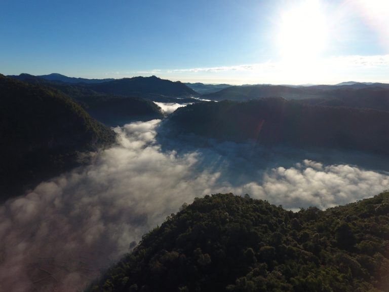
Mutraw District, Kawthoolei. Photo : KESAN
The practice of conservation through the establishment of community forest areas has also been officially recognised by the KNU, under the Kawthoolei Forest Policy. This objective of this policy is to officially recognise local village communities’ control and management of forest resources; to establish a process for local communities to manage, use, and benefit from forest resources and to conserve their tradition, culture, and improve their livelihoods; and, for local community to have a better understanding and recognize the importance as well as benefits of forests through direct participation in management and protection of forest resources.
These initiatives are grassroots efforts, led by the communities themselves. The KNU and civil society organisations, such as Karen Environmental Social and Environmental Network, have increasingly supported the efforts of local communities to conserve and strengthen their indigenous territories. As discussed, local communities, the KNU, and civil society organisations have been laying out the vision for the Salween Peace Park for many years. Yet, it was not until 2015, that local communities, civil society, and local authorities were able to come together to move the vision towards. Now, after 69 years of civil war, the Salween Peace Park has become a symbol of hope for the cultural survival of the Karen people and the political realisation of their struggle for self-determination. There are three main pillars or objectives which form the foundation of the Salween Peace Park: 1) Peace and self-determination, 2) Environmental integrity, and 3) Cultural survival.
“Land grabbing and extractive industries, including hydropower dams, are major drivers of armed conflict in Burma. More than 8,500 people have been forcibly displaced from their homes, land and property in Karen State as a direct result of armed conflict”
Indigenous Karen peoples’ governance and management rights over their ancestral territories date back many generations. However, before the 2012 ceasefire agreement, people were not concerned about officially demarcating boundaries or defining their land and natural resource management systems. Yet, following the 2012 ceasefire agreement, instances of land grabbing and natural resources exploitation accelerated, becoming more widespread. Rather than supporting the rights of local communities, Union Government legal frameworks related to land and natural resources, including the 2008 constitution, have led to increases in land confiscations, particularly in Union Government controlled and mixed administration areas. These pressures have led local communities, such as those in Mutraw, to define and demarcate their ancestral territories and land use systems in order to establish bottom-up protection mechanisms from predatory government and private business interests, and land and natural resource related legal frameworks.
Three Peace Park public consultations were held between 2016 and 2018, where the community laid out their visions “towards achieving ‘inclusive conservation’ and cultural preservation, while building peace through recognition of indigenous Karen people’s rights to self-determination over their ancestral territories in Mutraw District of Kawthoolei”[15] This community-led approach has led to the establishment of the Salween Peace Park Committee, who play a leading role in the drafting of the Salween Peace Park Charter, due to be ratified through popular vote. After the Salween Peace Park Charter has been ratified, the Peace Park Committee will guide its implementation according to the three main pillars; peace and self-determination, environmental integrity and cultural survival.
The Ravages of Conflict
Although these initiatives have all thus far had a notable impact on the communities involved, a significant barrier remains to promoting their expansion, and in some cases has even led to the cancellation of further proposed community-based initiatives. The key barrier is continued conflict and increased militarisation.
Land grabbing and extractive industries, including hydropower dams, are major drivers of armed conflict in Burma. More than 8,500 people have been forcibly displaced from their homes, land and property in Karen State as a direct result of armed conflict since the KNU signed the NCA in late 2015.
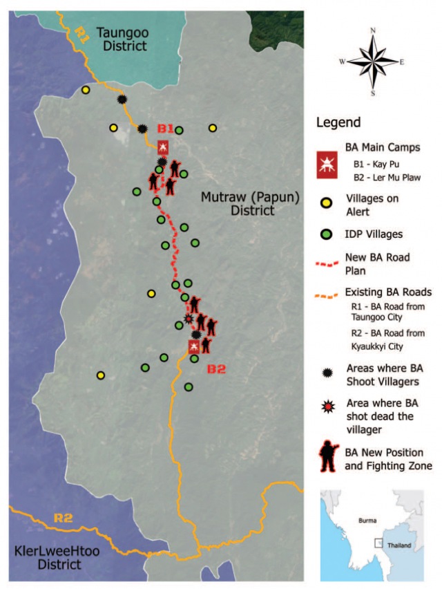
Map of Recent Conflict in Mutraw District and IDP Situation.
In September 2016, armed conflict broke out along the eastern access road leading to the Hatgyi dam site in Lu Pleh Township, Hpa-an District, as the Burma Army-led Borer Guard Force moved to assert military control over the dam site area. The fighting, which lasted for over two weeks, forced over 5,000 Karen villagers to flee their homes. Until today, these people have been unable to safely return to their villages, and the majority are now living as Internally Displaced Peoples in temporary shelters without access to humanitarian aid.
In March 2018, the Burma Army began the largest and most coordinated deployment of troops into Karen State’s Mutraw district since 2008.[16] More than 1,500 Burma Army troops crossed into KNU-controlled areas of Mutraw’s Luthaw township, breaching the terms of the 2015 Nationwide Ceasefire Agreement and provoking multiple clashes with the Karen National Liberation Army’s 5th Brigade. Troops serving under the Burma Army’s Southern Command indiscriminately targeted civilians, forcing more than 2,400 villagers to flee their land and homes. The majority of those displaced by the Burma Army’s military operations had only recently returned to rebuild their villages, farms, and livelihoods following decades of widespread armed conflict.
Villagers demonstrate for peace in Ler Mu Plaw, Mutraw District, Kawthoolei. Photo by Brennan O’Connor.
In the evening of April 5, 2018, Saw O Moo was ambushed and shot by the Burmese Army after coordinating and arranging humanitarian assistance for the Internally Displaced Persons (IDPs) in Ler Mu Plaw area of Mutraw District, Karen State. Saw O Moo was an indigenous Karen land rights defender, indigenous knowledge holder, and peace advocate who was also actively involved the Salween Peace Park, a local community initiative that strives for genuine peace, environmental conservation and cultural preservation.
Although KNLA authorities have confirmed Saw O Moo’s death, several attempts to retrieve the body have been unsuccessful, as Burma Army soldiers are shooting at anyone who approaches the area. As a result, Saw O Moo’s family has not been able to perform their Indigenous funeral rites.
The KNU and Burma Army are both signatories to the 2015 NCA, which prohibits the expansion of military infrastructure and troop reinforcements in ceasefire areas. However, beginning on March 4, 2018, at least eight Burma Army battalions[17] entered Luthaw, without prior agreement[18] from the KNLA, and begun constructing a military operations road to connect their military bases at Ler Mu Plaw and Kay Pu. If the road is built, Indigenous Karen villagers may be permanently displaced from their homes and ancestral village territories.
Building Peace and Self-determination from the Bottom-up
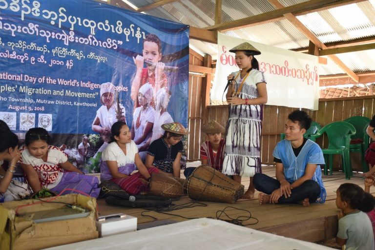
Indigenous Karen youth present their research in the Salween Peace Park. Photo from KESAN.
Seeking pathways to peace have become increasingly complex. The invasion and occupation of ethnic territories by the Burma Army has been followed by the expansion of Union Government administrative power which has come hand-in-hand with large-scale extractive industries, including large hydropower dams, agribusiness, and their associated infrastructure.
“Managing these territorial rights appropriately is vital for the survival of Karen culture, the conservation of biodiversity, and the building of peace and self-determination from the bottom-up”
The Salween Peace Park is becoming an indelible part of the Karen peoples historical struggle against oppression by the Burma Army and the Union Government of Myanmar. The Peace Park also defines the terms of peace in accordance with the vision of the people of Mutraw, who have stood together in defiance to demand something different for the future of their people. Karen communities have for years built and governed wildlife protection areas, community forests, food security programmes, seed banks, and traditional medicine forests and gardens with the aim of strengthening livelihoods and conservation. These communities have also pioneered projects seeking to identify the biodiversity present in the region, and strategize on how best to protect it. The Salween Peace Park draws together this knowledge and expertise while sharpening the Karen vision for self-determination. Despite the recent conflict and the Burma Army’s refusal to withdraw its military camps from Mutraw, the indigenous Karen people of Mutraw have used the Salween Peace Park to define their own democratic space and raise awareness about their struggle for a different way forward, based on building peace and trust from the bottom up.
###
KESAN (Karen Environmental Social Action Network) is a community-based, non-governmental, non-profit organization that works to improve livelihood security and to gain respect for indigenous people’s knowledge and rights in Karen State of Burma, where the violence and inequities of more than 60 years of civil war have created one of the most impoverished regions in the world.
###
Footnotes:
[1] Smith, Martin (1994) p.18
[2] Joliffe, Kim (2016) p.2
[3] Karen Information Center (KIC), “Karen Affairs Committee confirms names of seven official sub-tribes”, 5 May 2017. Accessible at: https://www.bnionline.net/en/news/karen-state/item/3004-karen-affairs-committee-confirms-names-of-seven-official-sub-tribes.html
[4] Joliffe, Kim (2016) p.2
[5]See Aung San-Attlee Agreement, January 27, 1947, available at: https://burmastar1010.files.wordpress.com/2011/06/44172419-aungsanatlee-agreement.pdf. See also Government of Burma Act (1935).[6] Tharckabaw, David (2015) Karen People’s Struggle for Equality and Freedom
[7] Committee for Internally Displaced Karen People (CIDKP) figure presented at “Symposium on the Salween Dams” June 27, 2003; estimated figure provided by KNU’s Mutraw District Administration; as cited in Karen Rivers Watch (KRW) (2004) Damming at Gunpoint, p. 1, p. 42
[8] Feeding figures provided by the Karen Office of Relief and Development (KORD) to KHRG. See KHRG report, Self-protection under strain (2010: 21)
[9] Joliffe, Kim (2016) “Ceasefire, Governance and Development” The Asia Foundation p. 34
[10] Joliffe, Kim (2016) p. 9
[11] Burma Environmental Working Group (2009) p.55; Karen Human Rights Group (2015) p.8
[12] Karen Human Rights Group (2015) p.8
[13] Karen Rivers Watch (2014) p.1; Karen Human Rights Group (2015) p.8
[14] KESAN (2017) The Salween Peace Park: A Scoping Study
[15] Karen News “International Day of the World’s Indigenous Peoples – Karen Community Groups Want Respect, Management Rights and Governance Over Ancestral Territories”, 12 August 2018, Accessible at: http://karennews.org/2018/08/international-day-of-the-worlds-indigenous-peoples-karen-community-groups-want-respect-management-rights-and-governance-over-ancestral-territories/
[16] Karen Peace Support Network (2018) The Nightmare Returns: Karen hopes for peace and stability dashed by Burma Army’s actions, accessible at: http://kesan.asia/index.php/resources/download/13-reports/122-the-nightmare-return-karen-hopes-for-peace-and-stability-dashed-by-burma-army-s-actions
[17] A report from Free Burma Rangers (FBR) names the eight battalions as Light Infantry Battalion (LIB) 20, LIB 351, LIB 435, LIB 598, LIB 558, LIB 432, LIB 596, LIB 560. See FBR report, They Are Running Again, This Time With Babies, 15 March 2018, accessible at: http://www.freeburmarangers.org/2018/03/15/running-time-babies-1700-villagers-flee-burma-army-attacks-builds-roadsnorthern-karen-state/
[18] “Movement of armed troops in the areas controlled by the other is allowed only after obtaining prior agreement.” 2015 NCA, Article 8 (b)